NWS UPDATE: Lake Effect Snow WARNINGS for Lewis and Oneida Counties


LEWIS COUNTY: LAKE EFFECT SNOW WARNING REMAINS IN EFFECT UNTIL 4 AM EST SATURDAY, NOVEMBER 19, 2022.
* WHAT...Heavy lake effect snow expected. Snow will occur across southwestern Lewis county, especially across the Tug Hill through this morning. Snow accumulations will range from 8 to 14 inches through today. Expect the bands to then shift to far northern Lewis county tonight into Friday night. Expected snow accumulations over far northern Lewis county Thursday night through Friday night will range from 8 to 16 inches. Winds gusting as high as 35 mph with produce patchy blowing snow.
* WHERE...Lewis county.
* WHEN...Until 4 AM EST Saturday.
* IMPACTS...Travel could be very difficult to impossible. The hazardous conditions could impact the morning or evening commute. The heavy snow could also bring down some tree limbs and cause scattered power outages.
PRECAUTIONARY/PREPAREDNESS ACTIONS...Heavy snow will fall in relatively narrow bands. If traveling, be prepared for rapidly changing road conditions and visibilities.
NORTHERN ONEIDA COUNTY: LAKE EFFECT SNOW WARNING REMAINS IN EFFECT UNTIL 2 AM EST FRIDAY, NOVEMBER 18, 2022.
* WHAT...Heavy lake effect snow expected. Total snow accumulations of 7 to 14 inches. The highest snow accumulations may reach up to 16 inches north of Camden.
* WHERE...Northern Oneida county.
* WHEN...Through 2 AM EST Friday.
* IMPACTS...Travel could be very difficult to impossible. The hazardous conditions could impact the morning or evening commute.
PRECAUTIONARY/PREPAREDNESS ACTIONS...If you must travel, keep an extra flashlight, food, and water in your vehicle in case of an emergency.
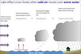
National Weather Service images.
