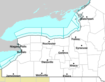
Wind Advisory for Lewis and Jefferson Counties AND Lake Effect Snow Warning in effect from 9PM this evening until Tuesday evening
FOR LEWIS AND JEFFERSON COUNTIES--...WIND ADVISORY IN EFFECT UNTIL 11 AM EDT TUESDAY... ...HIGH WIND WARNING IS CANCELLED... * WHAT...Southwest winds 25 to 35 mph with gusts up to 50 mph. * WHERE...Jefferson and Lewis Counties. * WHEN...Until 11 AM EDT Tuesday. * IMPACTS...Gusty winds will blow around unsecured objects. Tree limbs could be blown down and a few power outages may result.
Lake Effect Snow Warning...LAKE EFFECT SNOW WARNING IN EFFECT FROM 9 PM THIS EVENING TO 8 PM EDT TUESDAY... * WHAT...Heavy lake effect snow expected. Total snow accumulations 6 to 12 inches in the most persistent bands across the Tug Hill Plateau, with 3 to 5 inches elsewhere. Winds gusting as high as 45 mph will produce blowing and drifting snow late tonight through Tuesday. There may be a brief period of sleet and freezing rain during the transition to snow this evening, with ice accumulations of up to a tenth of an inch in some areas. * WHERE...Jefferson and Lewis Counties. * WHEN...From 9 PM this evening to 8 PM EDT Tuesday. * IMPACTS...Travel will be difficult with snow covered roads and poor visibility. The hazardous conditions will impact the Tuesday morning and evening commutes. Gusty winds will down tree branches and cause isolated power outages. * ADDITIONAL DETAILS...A rapid drop in temperatures late this evening may produce very icy conditions on untreated roads, sidewalks, and parking lots. PRECAUTIONARY/PREPAREDNESS ACTIONS... Heavy snow will fall in relatively narrow bands. If traveling, be prepared for rapidly changing road conditions and visibilities. Submit snow reports through our website or social media.