NWS: Flood Watch for entire listening area Wednesday, July 10, 2024

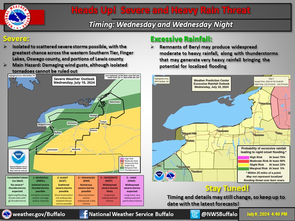
PHOTO: The remnants of Beryl will impact the region Wednesday into Wednesday night bringing areas of heavy rainfall and potential localized flooding, according to the NWS Buffalo, NY Office. Severe thunderstorms will also be possible with the main threat being damaging winds, although isolated tornadoes cannot be ruled out.
***Listen to our latest on-air coverage with NWS Meteorologist Kaitlyn Lardeo (Binghamton, NY Office) for more details:
Jefferson, Lewis & Oswego Counties: FLOOD WATCH IN EFFECT FROM NOON EDT TODAY THROUGH WEDNESDAY EVENING.
* WHAT...Flash flooding caused by excessive rainfall is possible.
* WHERE...A portion of central New York, including the following counties: Jefferson, Lewis and Oswego.
* WHEN...From Noon EDT Wednesday through the evening.
* IMPACTS...Excessive runoff may result in flooding of rivers, creeks, streams, and other low-lying and flood-prone locations. Flooding may occur in poor drainage and urban areas.
* ADDITIONAL DETAILS...Heavy rain associated with the remnants of Beryl will produce 2 to 3 inches of rain with locally higher amounts possible. Heavy rainfall rates associated with thunderstorms could produce localized flash flooding this afternoon and this evening.
PRECAUTIONARY/PREPAREDNESS ACTIONS...You should monitor later forecasts and be prepared to take action should Flash Flood Warnings be issued.
Central New York & Oneida County: FLOOD WATCH IN EFFECT FROM NOON EDT TODAY THROUGH WEDNESDAY EVENING.
* WHAT...Flash flooding caused by excessive rainfall is possible.
* WHERE...A portion of central New York, including the following areas, Madison, Northern Oneida, Onondaga and Southern Oneida.
* WHEN...From Noon EDT Wednesday through the evening.
* IMPACTS...Excessive runoff may result in flooding of rivers, creeks, streams, and other low-lying and flood-prone locations.
PRECAUTIONARY/PREPAREDNESS ACTIONS...You should monitor later forecasts and be prepared to take action should Flash Flood Warnings be issued.
Old Forge & Western Adirondacks: FLOOD WATCH REMAINS IN EFFECT FROM NOON EDT WEDNESDAY THROUGH THURSDAY MORNING.
* WHAT...Flash flooding caused by excessive rainfall continues to be possible.
* WHERE...Portions of the southern Adirondacks, upper Hudson Valley, Lake George area, and northern Washington County.
* WHEN...From Noon EDT Wednesday through Thursday morning.
* IMPACTS...Excessive runoff may result in flooding of rivers, creeks, streams, and other low-lying and flood-prone locations. Flooding may occur in poor drainage and urban areas.
* ADDITIONAL DETAILS...The remnants of Beryl will interact with a warm front, leading to 1 to 3 inches of rain with locally higher amounts possible. Heavy rainfall rates in thunderstorms could produce localized flash flooding Wednesday afternoon into Wednesday night.
PRECAUTIONARY/PREPAREDNESS ACTIONS...You should monitor later forecasts and be prepared to take action should Flash Flood Warnings be issued.
NWS images.
